Saturday, July 4, 2009

54-Satellite Aerial Map using KML to embed information on the map


KML – Aerial Satellite Map (from Google Earth) – of Paradise Island at One & Only Ocean Club Paradise Island - Po Box N 4777, Paradise Island, Bahamas. The URL is: http://maps.google.com/maps?q=The+Ocean+Club,+Paradise+Island,+Bahamas&sll=25.0836,-77.3195&sspn=0.0107655,0.0150392&ie=UTF8&v=2.2&cv=5.0.11733.9347&hl=en&latlng=25085910,-77319000,715816747728306402&ei=fA1QSu2rFZvcMI7gof8J&cd=1&dtab=5. This map provides detailed information embedded in the aerial map itself such as the location of the Ocean Club, and other cool features of the Atlantis Paradise Island resort.

Thursday, July 2, 2009

19 - Doppler Radar


This Dopplar radar image is from URL: http://www.weatherusa.net/blog/images/doppler-orlando-1943.gif, and depicts weather data to forcasters using satellites that utilize the Dopplar effect of returned echoes from targets (e.g. raindrops).

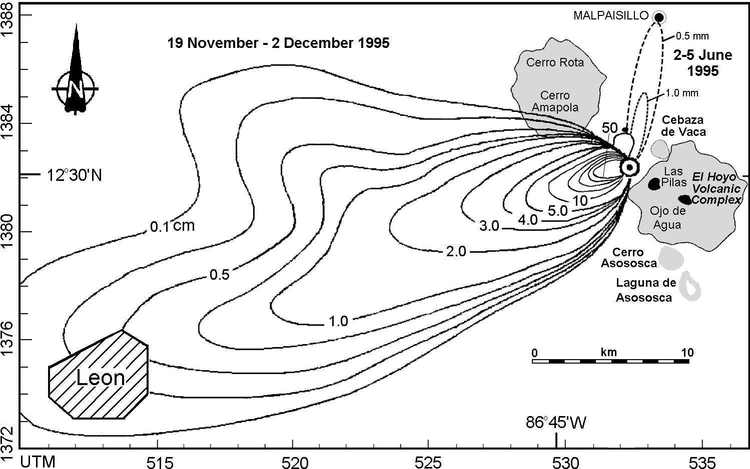
24-Isopach Map


This isopach map at: http://www.geo.mtu.edu/volcanoes/central_america/nicaragua/cerro_negro/gvn/images/2012neg4.jpg shows ashfall distribution over a geographic area in a given time period. An isopach map is a contour map showing the distribution and thickness of some substance, such as thickness of a stratigraphic layer, or distribution/density of ashfall.


28-DEM (Digital Elevation Map)


The URL: http://www.terrainmap.com/ provides information on a combined set of maps. That is, overlaying both Digital Line Graph (DLG) data on a Digital Elevation Map (DEM). In this example below, rasterized vector data has been overlayed on a DEM to produce the drainage basin map here.


39-Bilateral graph


This bilateral graph at: http://www.rowperfect.com.au/innovative_training.html shows data points represented both above and below a zero line. In this specific example, shows the speed of a boat and rower relative to a common center of gravity.

48-Histogram


This histogram shows multiple disparate but related pieces of data related to a geographic area. In this example, for a total population across numerous geographic locations, comparisons of total dog ownership to vet visits is depicted. The URL is: http://www.alignstar.com/screenshots.html


45-Windrose


This Windrose map at URL: http://www.emeraldinsight.com/fig/1820250403012.png. It shows wind direction and wind speed in a particular geographic location (e.g. at an airport).